


Mô tả của V-Navi
V-Navi - The full-featured navigation app for Android that brings you quicker to your goal! Works in conjuction with various apps (e.g., "Das Telefonbuch", "Das Örtliche", among others), even free of charge, as conditions may apply.
ATTENTION: Navigation can be started in Germany, Austria, Switzerland and optional in Western Europe.
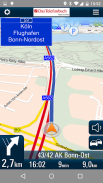
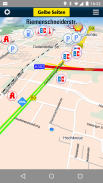
With the high quality traffic you will get a complete overview of the market. Traffic congestion traffic congestion avoidance. The V-Navi: you will thus always the best route. The traffic density is displayed in red, yellow, green in the map. Germany, Annual, 30 days free of charge with no obligation to buy. Internet connection is required.
The new version of V-Navi works with offboard maps (with limited functionality) to enable immediate navigation after download. The map data for Germany, Austria and Switzerland is downloaded once at the start of the first use of V-Navi (ca. 300 MB). Thereafter, an Internet connection is only necessary for a short time at app-startup.
HIGHLIGHTS:
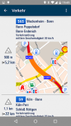
- Current traffic situation in Germany (INRIX), traffic reports traffic congestion avoidance and traffic density display
- Offboard vector mode after first installation
- Lane info assistant
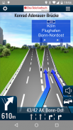
- Reality view (reality like display of turn actions on motorways)
- Map data is stored on the device
- Quick destination entry (address, points of interest (POIs), favorites, etc.)
- Updates free of charge
- Computation and display of alternate routes
- Display of speed limits and speeding alerts
- Support for portrait and landscape display
- Quick-Menu
- New and ergonomic menu
- Optimized map view
- Save & load itineraries
FUNCTIONS:
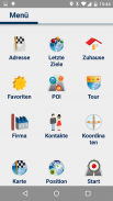
Destination entry:
- Address entry with an automatic pop-up list of cities, etc.
- Address search by country
- House-number-exact geocoding when online
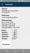
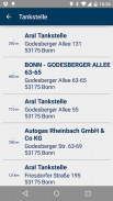
- POI search
- Destination selection directly on the map
- Entry of destination coordinates and crossroads
- Destination selection from a list of recent destinations and from the favorites list
- Use of contacts in the address book as destinations
Navigation:
- Profiles for car, pedestrians, recreational vehicles and caravans
- Adjustable routing: quickest, shortest
- Voice-guided navigation
- Spoken street names through text-to-speech
- Sinage display (motorway signs)
- Speed-dependent zoom and crossroad-zoom
- Stretch-block: Automatic route recalculation (e.g., for the next 0.5-10 km along the route to avoid a traffic jam)
- Avoidance of motorways, ferries, and tollways
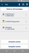
- Itineraries: Management of intermediate stops, saving and loading of itineraries
Map Display and Functionality
- View modes: 3D, 2D in the direction of travel, 2D North up
- Daytime and nighttime view modes, automatic switching (geodaylight)
- Route overview
- Display of POIs with setting of the destination directly from a POI icon on the map
CONDITIONS OF USE:
V-Navi may be used free of charge for a test period of 30 days. Numerous applications, such as the telephone directory apps "Das Telefonbuch" and "Das Örtliche" provide you with the means of continuing to use V-Navi free of charge by starting V-Navi directly from within the apps. Please consult the Conditions of Use in each of the respective apps.
The traffic data to 30 days (trial period) are free to use and are then as in-app purchase.
AVAILABLE in-app purchase options (for pricing, see under "In-App Purchases"):
- Traffic data for Germany (INRIX)
- Navigation und maps for Germany, Austria, and Switzerland (D-A-CH)
- Navigation und maps for Western Europe
The map data and navigation for Western Europe cover the following countries:
Germany (D),Austria (A),Switzerland (CH),Liechtenstein,Andorra,Belgium,Denmark,Finnland,France,Great Britain,Ireland,Italy,Luxemburg,Monaco,Netherlands,Norway,Portugal,San Marino,Spain,Sweden
See more at https://www.facebook.com/Map-and-Route-1454577274845960/
V-Navi - Ứng dụng chuyển hướng đầy đủ tính năng cho Android mang đến cho bạn nhanh hơn đến mục tiêu của bạn! Làm việc trong conjuction với các ứng dụng khác nhau (ví dụ, "Das Telefonbuch", "Das Örtliche", trong số những người khác), thậm chí miễn phí, điều kiện có thể áp dụng.
Chú ý: Danh mục có thể được bắt đầu ở Đức, Áo, Thụy Sĩ và tùy chọn ở Tây Âu.
Với giao thông chất lượng cao, bạn sẽ có được một cái nhìn tổng quan hoàn chỉnh của thị trường. Tắc nghẽn giao thông tắc nghẽn giao thông tránh. V-Navi: bạn sẽ như vậy, luôn luôn là con đường tốt nhất. Mật độ giao thông sẽ được hiển thị bằng màu đỏ, màu vàng, màu xanh lá cây trong bản đồ. Đức, hàng năm, 30 ngày miễn phí với không có nghĩa vụ phải mua. kết nối Internet là bắt buộc.
Phiên bản mới của V-Navi làm việc với bản đồ offboard (với tính năng hạn chế) để cho phép chuyển hướng ngay lập tức sau khi tải về. Dữ liệu bản đồ ở Đức, Áo và Thụy Sĩ được tải xuống một lần vào lúc bắt đầu của việc sử dụng đầu tiên của V-Navi (khoảng 300 MB). Sau đó, một kết nối Internet chỉ cần thiết trong một thời gian ngắn ở ứng dụng-khởi động.
ĐIỂM NHẤN:
- Tình trạng giao thông hiện tại ở Đức (INRIX), giao thông báo cáo tình trạng tắc nghẽn giao thông tránh và mật độ giao thông hiển thị
- Chế độ vector Offboard sau khi cài đặt đầu tiên
- Trợ lý thông tin ngõ
- Xem Reality (thực tế như hiển thị các hành động lần lượt trên đường cao tốc)
- Bản đồ dữ liệu được lưu trữ trên thiết bị
- Mục đích đến nhanh (địa chỉ, điểm quan tâm (POI), yêu thích, vv)
- Cập nhật miễn phí
- Tính toán và hiển thị các tuyến đường thay thế
- Hiển thị các giới hạn tốc độ và cảnh báo quá tốc độ
- Hỗ trợ cho chân dung và phong cảnh màn hình
- Quick-Menu
- Mới và đơn ergonomic
- Tối ưu hóa bản đồ
- Lưu và tải hành trình
CHỨC NĂNG:
mục Điểm đến:
- Nhập địa chỉ với một danh sách các pop-up tự động của thành phố, vv
- Tìm địa chỉ của đất nước
- Nhà-số-chính xác mã hóa địa lý khi trực tuyến
- POI tìm kiếm
- Lựa chọn điểm đến trực tiếp trên bản đồ
- Entry của điểm tọa độ và ngã tư đường
- Lựa chọn điểm đến từ một danh sách các điểm đến gần đây và từ danh sách ưa thích
- Sử dụng các địa chỉ liên lạc trong sổ địa chỉ là những điểm đến
Dẫn đường:
- Cấu hình cho xe, người đi bộ, xe giải trí và các đoàn lữ hành
- Định tuyến điều chỉnh được: nhanh nhất, ngắn nhất
- Hướng dẫn đường bằng giọng nói
- Nói tên đường phố thông qua văn bản thành giọng nói
- Hiển thị Sinage (dấu hiệu đường cao tốc)
- Zoom Tốc độ phụ thuộc và ngã tư-zoom
- Căng-block: tự động tính toán lại tuyến đường (ví dụ, cho 0,5-10 km tiếp theo cùng con đường để tránh ùn tắc giao thông)
- Tránh đường cao tốc, bến phà, và tollways
- Hành trình: Quản lý các điểm dừng trung gian, tiết kiệm và tải của hành trình
Bản đồ hiển thị và tính năng
- Xem chế độ: 3D, 2D theo hướng du lịch, 2D Bắc lên
- Ban ngày và ban đêm xem chế độ, tự động chuyển đổi (geodaylight)
- Tổng quan tuyến
- Hiển thị POI với thiết lập của các điểm đến trực tiếp từ một biểu tượng POI trên bản đồ
ĐIỀU KIỆN SỬ DỤNG:
V-Navi có thể được sử dụng miễn phí trong một thời gian thử thách là 30 ngày. Hàng loạt ứng dụng, chẳng hạn như các ứng dụng danh bạ điện thoại "Das Telefonbuch" và "Das Örtliche" cung cấp cho bạn với các phương tiện tiếp tục sử dụng V-Navi miễn phí bằng cách bắt đầu V-Navi trực tiếp từ bên trong ứng dụng. Vui lòng tham khảo Điều kiện sử dụng trong từng ứng dụng tương ứng.
Các dữ liệu lưu lượng đến 30 ngày (thời gian dùng thử) được miễn phí để sử dụng và sau đó là mua trong ứng dụng.
SẴN tùy chọn mua trong ứng dụng (đối với giá cả, thấy dưới "In-App Mua"):
- Dữ liệu giao thông cho Đức (INRIX)
- Di chuyển bản đồ und ở Đức, Áo và Thụy Sĩ (D-A-CH)
- Di chuyển bản đồ und cho Tây Âu
Dữ liệu bản đồ và định vị cho Tây Âu bao gồm các nước sau:
Đức (D), Áo (A), Thụy Sĩ (CH), Liechtenstein, Andorra, Bỉ, Đan Mạch, Finnland, Pháp, Anh, Ireland, Ý, Luxembourg, Monaco, Hà Lan, Na Uy, Bồ Đào Nha, San Marino, Tây Ban Nha, Thụy Điển
Xem thêm tại https://www.facebook.com/Map-and-Route-1454577274845960/
V-Navi - The full-featured navigation app for Android that brings you quicker to your goal! Works in conjuction with various apps (e.g., "Das Telefonbuch", "Das Örtliche", among others), even free of charge, as conditions may apply.
ATTENTION: Navigation can be started in Germany, Austria, Switzerland and optional in Western Europe.
With the high quality traffic you will get a complete overview of the market. Traffic congestion traffic congestion avoidance. The V-Navi: you will thus always the best route. The traffic density is displayed in red, yellow, green in the map. Germany, Annual, 30 days free of charge with no obligation to buy. Internet connection is required.
The new version of V-Navi works with offboard maps (with limited functionality) to enable immediate navigation after download. The map data for Germany, Austria and Switzerland is downloaded once at the start of the first use of V-Navi (ca. 300 MB). Thereafter, an Internet connection is only necessary for a short time at app-startup.
HIGHLIGHTS:
- Current traffic situation in Germany (INRIX), traffic reports traffic congestion avoidance and traffic density display
- Offboard vector mode after first installation
- Lane info assistant
- Reality view (reality like display of turn actions on motorways)
- Map data is stored on the device
- Quick destination entry (address, points of interest (POIs), favorites, etc.)
- Updates free of charge
- Computation and display of alternate routes
- Display of speed limits and speeding alerts
- Support for portrait and landscape display
- Quick-Menu
- New and ergonomic menu
- Optimized map view
- Save & load itineraries
FUNCTIONS:
Destination entry:
- Address entry with an automatic pop-up list of cities, etc.
- Address search by country
- House-number-exact geocoding when online
- POI search
- Destination selection directly on the map
- Entry of destination coordinates and crossroads
- Destination selection from a list of recent destinations and from the favorites list
- Use of contacts in the address book as destinations
Navigation:
- Profiles for car, pedestrians, recreational vehicles and caravans
- Adjustable routing: quickest, shortest
- Voice-guided navigation
- Spoken street names through text-to-speech
- Sinage display (motorway signs)
- Speed-dependent zoom and crossroad-zoom
- Stretch-block: Automatic route recalculation (e.g., for the next 0.5-10 km along the route to avoid a traffic jam)
- Avoidance of motorways, ferries, and tollways
- Itineraries: Management of intermediate stops, saving and loading of itineraries
Map Display and Functionality
- View modes: 3D, 2D in the direction of travel, 2D North up
- Daytime and nighttime view modes, automatic switching (geodaylight)
- Route overview
- Display of POIs with setting of the destination directly from a POI icon on the map
CONDITIONS OF USE:
V-Navi may be used free of charge for a test period of 30 days. Numerous applications, such as the telephone directory apps "Das Telefonbuch" and "Das Örtliche" provide you with the means of continuing to use V-Navi free of charge by starting V-Navi directly from within the apps. Please consult the Conditions of Use in each of the respective apps.
The traffic data to 30 days (trial period) are free to use and are then as in-app purchase.
AVAILABLE in-app purchase options (for pricing, see under "In-App Purchases"):
- Traffic data for Germany (INRIX)
- Navigation und maps for Germany, Austria, and Switzerland (D-A-CH)
- Navigation und maps for Western Europe
The map data and navigation for Western Europe cover the following countries:
Germany (D),Austria (A),Switzerland (CH),Liechtenstein,Andorra,Belgium,Denmark,Finnland,France,Great Britain,Ireland,Italy,Luxemburg,Monaco,Netherlands,Norway,Portugal,San Marino,Spain,Sweden
See more at https://www.facebook.com/Map-and-Route-1454577274845960/

V-Navi - Thông tin APK
Phiên bản APK: 4.9.7Gói: de.mapandroute.android.vnaviỨng dụng cùng danh mục
Bạn cũng có thể thích...


